
Patagonia Travel Guide: Everything You Need to Know
Patagonia is one of the most extraordinary wilderness destinations on earth. The region at the southern tip of South America, shared between Chile and Argentina, contains landscapes of a scale and intensity that most travelers describe as genuinely humbling: the granite towers of Torres del Paine, the vast ice fields of the Southern Patagonian Ice Field, the turquoise lakes of Argentine Patagonia, and the windswept steppe that stretches in every direction until it meets the Andes or the Atlantic Ocean.
This Patagonia travel guide covers everything visitors need to know: the essential destinations on both sides of the border, the trekking options from casual day walks to multi-week expeditions, the best time to visit, how to get there, and the practical details that make navigating one of the world’s most remote and rewarding destinations straightforward.
Torres del Paine National Park is the centerpiece of Chilean Patagonia and one of the great national parks in the world. The park covers 242,000 hectares of Andean peaks, glaciers, rivers, and lakes in the far south of Chile. The three granite towers that give the park its name rise 2,850 meters and are the most iconic image of Patagonian wilderness in the world.
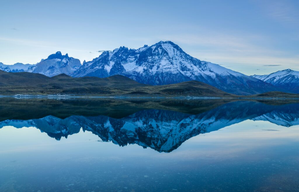
The park contains the Paine Massif, a dramatic mountain range including the towers, the horns (Los Cuernos), and Mount Paine Grande, all reflected in the extraordinary turquoise water of Lake Pehoe. Glaciers calve directly into Lake Grey. Condors ride the thermals above the steppe. The wildlife in the park includes guanacos, foxes, pumas, and Andean condors in densities rarely seen elsewhere.
- Entry fee: approximately 21,000 CLP (around $25 USD) per adult
- Nearest town: Puerto Natales (110 km north), the gateway and supply base
- Access: 3-hour bus or transfer from Puerto Natales
The W Trek is the most popular multi-day hiking route in Torres del Paine, named for the W-shaped path it traces across the park over 4 to 5 days. The route connects the three main highlights of the park: the Mirador Las Torres viewpoint at the base of the granite towers, the Valle del Frances glacier viewpoint, and the Grey Glacier at the edge of the Southern Ice Field.
The trek is best done from east to west, arriving at the Torres viewpoint on the first morning for the best chance of clear weather. The mountain huts (refugios) along the route provide accommodation with dinner and breakfast included, eliminating the need to carry camping gear. Spaces in the refugios sell out months in advance for the October to March season.
- Duration: 4 to 5 days
- Distance: approximately 80 kilometers
- Difficulty: moderate. No technical climbing required
- Book: refugios and campsites at vertice.cl and fantastico-sur.com, 4 to 6 months ahead for peak season
The O Circuit is the full loop around the Paine Massif, adding the remote and spectacular back side of the park to the W route for a total of 8 to 10 days. The additional sections cross the John Gardner Pass (the highest point on the route at 1,241 meters) and descend into the most dramatic scenery in the park, with views of the Southern Patagonian Ice Field that most visitors to Torres del Paine never see.
The back circuit sees significantly fewer hikers than the W route. Camping is mandatory for most of the additional sections as there are no refugios on the back side. A self-sufficient camping setup and solid hiking fitness are required.

The granite towers of Torres del Paine at dawn. The three towers rise 2,850 meters and are the defining image of Patagonian wilderness. Photo by Chris Stenger on Unsplash.
El Chalten is a small village in Argentine Patagonia built specifically as a trekking base for the Mount Fitz Roy and Cerro Torre massifs in Los Glaciares National Park. The village has no entry fee for the national park and the trail system radiating from the town into the mountains is exceptional. The Laguna de los Tres hike to the viewpoint directly below Fitz Roy’s north face is one of the finest day hikes in South America.
El Chalten operates on a completely different scale from Torres del Paine: smaller, cheaper, less developed, and with a hiking culture that feels genuinely local rather than heavily touristed. Accommodation is inexpensive, the food is excellent for the price, and the hiking is world-class.
- Access: 220 km north of El Calafate by road (3 hours)
- Best day hike: Laguna de los Tres (4 to 5 hours each way, 1,200m elevation gain)
- No park entry fee required
The Perito Moreno Glacier near El Calafate in Argentine Patagonia is one of the most accessible glaciers in the world and one of the very few that is still advancing rather than retreating. The glacier is 5 kilometers wide and 60 meters high at its face, and calves enormous ice blocks into Lake Argentino in thunderous collapses that can be watched from a network of elevated walkways a few meters from the ice.
Day tours from El Calafate include boat trips along the glacier face and ice trekking tours that walk directly onto the glacier surface in crampons. The Perito Moreno is extraordinary without any additional activities, but the ice trekking gives an experience of scale that viewing from the walkways alone cannot provide.

The turquoise waters of Torres del Paine National Park with the Paine Massif behind. The extraordinary color comes from glacial flour suspended in the meltwater from the surrounding glaciers.
| Period | Season | Conditions | Notes |
|---|---|---|---|
| November to March | Summer | Warmest, longest days | Peak season, book months ahead |
| December to February | High summer | Best weather probability | Most crowded, highest prices |
| October and April | Shoulder season | Variable, fewer people | Good conditions, better prices |
| May to September | Winter | Cold, many facilities closed | For experienced winter trekkers only |
November to March is the Patagonian summer and the only realistic window for most trekkers. December to February offers the longest daylight hours (up to 17 hours) and the best probability of clear weather, though wind is always present and weather changes can be rapid and extreme at any time of year.
October and April are the shoulder months with significantly fewer visitors, lower accommodation prices, and still-good trekking conditions. October brings spring wildflowers. April offers autumn colors on the lenga beech trees that line the valley trails in colors of orange and red that rival any temperate forest in the world.
- Chilean side (Torres del Paine): fly to Punta Arenas from Santiago (3 hours) or direct international flights. From Punta Arenas, bus or transfer to Puerto Natales (3 hours), then bus or transfer to the park (2 hours)
- Argentine side (El Chalten, Perito Moreno): fly to El Calafate from Buenos Aires (3 hours) or Bariloche. El Calafate has direct bus connections to El Chalten (3 hours) and the Perito Moreno Glacier (1.5 hours)
- Crossing the border: the crossing between Puerto Natales and El Calafate is a full-day journey (6 to 8 hours by bus) crossing the Chilean-Argentine border. Book this bus well in advance in peak season
- The Carretera Austral: the famous Route 7 running the length of Chilean Patagonia is best explored by rental car or bicycle and takes 2 to 3 weeks to drive properly
Puerto Natales is the gateway town for Torres del Paine, 110 kilometers north of the park entrance. The town has excellent guesthouses, gear rental shops, and supermarkets for stocking up before a trek. It is significantly cheaper than staying inside the park and the 2-hour transfer to the park entrance is straightforward. Most travelers spend 1 to 2 nights in Puerto Natales before and after their trek.
El Chalten is one of the most charming small towns in South America. Built in 1985 by the Argentine government specifically to assert sovereignty over the disputed territory, it has grown into a genuine trekking community of hostels, craft breweries, and excellent small restaurants. The trails begin at the edge of the village and most day hikes require no transport from town. Accommodation ranges from camping to comfortable guesthouses.
- Waterproof jacket and trousers: non-negotiable. Rain and wind can arrive within minutes regardless of morning sunshine
- Wind layer: a windproof mid-layer separate from your waterproof is essential in the exposed passes
- Trekking poles: enormously helpful on the descent sections and in high wind
- Gaiters: the trails in wet conditions involve significant mud. Gaiters protect boots and legs effectively
- Sunscreen and sunglasses: the UV at altitude in clear Patagonian weather is intense. The reflection off snow and glaciers amplifies it
- Headtorch: essential for early morning starts to reach viewpoints before other groups
- Cash in local currency: many park facilities and small towns have limited card payment. Carry enough pesos (Chilean and Argentine) for the duration
Patagonia changes the scale at which you experience landscape. The mountains are larger than you expect. The wind is stronger. The distances between things are greater. The silence in the valleys, when the wind briefly drops, is more complete than anywhere you have been. It is one of those rare destinations that genuinely exceeds even very high expectations.
Plan carefully, book the refugios the moment they open, pack for every weather condition, and give yourself enough time to move slowly through a landscape that is too large and too extraordinary to rush. This Patagonia travel guide gives you the foundation. The wind will provide the rest.
Ready to Plan Your Patagonia Trip?
Discover more South America guides, trekking routes, and Americas travel tips on Tripfavor.
Explore Tripfavor →